Waterway Guide Logo
  • SUBSCRIBE
  • Explore
    • Explorer
    • Destinations
    • Marinas
      • Map
      • Directory
    • Services
      • Map
      • Directory
    • Anchorages & Free Docks
      • Map
      • Directory
    • Bridges & Locks
      • Map
      • Directory
    • Navigation Alerts
      • Map
      • Directory
    • Fuel
      • Diesel
      • Gas
      • Fuel Price List
  • Download The App
  • Destinations
  • Knowledge Center
  • Ship Store
    • Ship Store Home
    • Great Lakes Volume 1
    • Great Lakes Volume 2
    • Northern
    • Chesapeake Bay
    • Mid-Atlantic
    • Southern & Gulf Coast
    • Bahamas
    • Cuba
    • Caribbean
  • Urgent Alerts Urgent Alerts
  • Forgot Password?
    Or log in with:
    facebook
    apple
Modal title

Modal body text goes here.

Log In
Forgot Password?
Or log in with:
facebook
apple

Thanks for your valuable feedback!
Back to the Waterway Explorer

View in Waterway Explorer

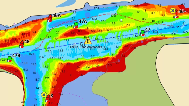
NC: Lockwoods Folly, shoaling MM 321.5

  • Date Reported: Jun 12, 2025
  • Reporter: Bob423
  • Source: User
  • Description:

    Update 5/11/2025. Lockwoods Folly has been dredged to 12.5 on the straight through path. The shore route has 8 MLLW. 

    Lockwoods Folly has been dredged, but the buoys will not be moved to show the dredged path. The path through Lockwoods Folly alternates between the straight-through route and the shore route, requiring the relocation of buoys with every shoaling event. You'll notice that G47A remains to mark the shore route. If you're aware of the dredging being completed, you can sight along the G47B to G47 line and find the dredged channel for 12 to 14 MLLW - or follow the revised Bob423 track in blue on the 4/22/2025 USACE survey.

    Note the location of G47A, It marks the remaining shoal that has to be avoided when taking the shore route. In past dredging events, G47A was eliminated and R46A was moved to mark the northern edge of the dredged channel - but not this time, nor in the future. R46A will remain where it's at to mark the shore route.The simple way to find the dredged route is to follow the Bob423 track in blue dated 051125 or later. When the straight-through route shoals again (it will), then the shore route will already be in Aqua Map or Navionics for avoiding the shoaling.

    Use this Alert to know the depths for each route and decide which path gives you the depths you need for your draft and the tide at the time of your passage.


    USACE = US Army Corps of Engineers
    ATONs = Aids TO Navigation such as buoys and daymarks
    Aqua Map = a navigation app for Apple and Android devices
    Bob423 Long Track = blue dotted line
    How to download tracks

  • Lat / Lon: N 33° 55.255' / W 078° 14.127'

DISCLAIMER: Waterway Guide Media provides Navigation Alerts as a resource for planning purposes only and does not warrant the information included in the postings as accurate. Advice and descriptions contained in the alerts are not for navigation.


4 Boater Comments

These are observations from the boating community. Waterway Guide information is verified regularly and all efforts will be made to validate any new updates submitted here. Thank you for taking the time to share comments about your experience.

Waterway Guide reserves the option of editing reviews and comments for grammar, clarity and the removal of defamatory or potentially slanderous language. When appropriate, reviews are forwarded to businesses for response prior to being made public. We will make every effort to be objective and impartial when posting reviews, but do not publicize details of disputes between parties.

Current Review Policies

Waterway Guide reserves the option of editing reviews and comments for grammar, clarity and the removal of defamatory or potentially slanderous language. When appropriate, reviews are forwarded to businesses for response prior to being made public. We will make every effort to be objective and impartial when posting reviews, but do not publicize details of disputes between parties.

  • Comments are reviewed and/or verified by Waterway Guide staff and do not post immediately. Please use a valid email address so that we can contact you if we need clarification (email address will not be published).
  • Name will be published. Anonymous comments may not be posted.
  • Comments will be shared with the reviewed marina to offer them an opportunity to respond. If they choose to do so, the marina’s comments may also be posted in response to the original comment.
  • Comments containing foul or obscene language will be rejected or returned for resubmission.
  • Comments containing personal attacks will be rejected or returned for resubmission.
  • Off-topic content will be rejected.
  • Comments must describe commenter's personal experience – “hearsay” reports will be rejected.
  • Comments must be understandable and clear enough to inform other boaters.
  • URL links are allowed only if they inform the content – no “advertising” your business or blog.

  • Comment by: George Rod Nelson on Apr 11, 2025
    Vessel Type: Power
    LOA: 40'
    Draft: 4.5'

    Came through this area on 4/10 about 2 hours before low tide. A dredge is sitting on the shoal marked by G47a. Followed Bob423 track closely and saw no less than 12ft. There is a yellow can to the south of 47a which I believe is associated with the dredge operation and not an ATON.

    View location on the Waterway Guide Explorer


  • Comment by: Cam &, Viatori, on Apr 9, 2025
    Vessel Type: Power
    LOA: 47'
    Draft: 4.0'

    We came through today at 11:00a EST, and saw shallows of 6.4' under the hull. Depths were mostly above 10' under the hull. Wilko was in the channel dreging today.

    View location on the Waterway Guide Explorer


  • Comment by: Hubert Hopkins on Oct 29, 2024
    Vessel Type: Power
    LOA: 42'
    Draft: 4.0'

    The channel markers have been moved to reflect the Bob423 track as of Oct 29, 2024.

    View location on the Waterway Guide Explorer


  • Comment by: Susan Cole on Apr 9, 2024
    Vessel Type: Power
    LOA: 42'
    Draft: 4.0'

    Atons have been moved showing straight channel through.

    View location on the Waterway Guide Explorer

Comment on this Navigation Alert

The name field is required.

The email field is required.

  Display?

LOA is required.

Draft is required.


Yes, sign me up for the News & Navigation Alerts.

Sending...

Review Policies
  • Explorer
  • Download The App
  • Destinations
  • Knowledge Center
  • Shop
Popular Resources
Fuel Price Reports
View the Directory
Subscribe To Our Newsletter
logo
About Us
Contact
Advertise
Careers
Legal
Affiliate Program
Marina Login
© 2025 Waterway Guide Media LLC: All rights reserved. No part of this site may be reproduced without written permission.
Waterway Guide is proud to be a sponsor of:
aglca
mtoa
seven-seas
us-sailing
abm
Apple Sign-In
Note: If you already have a Waterway Guide account please choose, when prompted, to share your email with us so we can sign you in to your proper account.
Newsletter Sign-Up

The bow is at the end of the boat.

The captcha question was answered incorrectly.

The email is invalid. Please close the modal window and try again.

Signing-up...