The ICW areas mentioned in this Bulletin are only the recent changes, not a complete guide to all shoaling or problems. Additional resources are available in the Waterway Guide digital publication 2024 ICW Cruising Guide and at Bob423 Guides. See Bulletins from previous weeks for additional spring migration problem areas
MM 579.9 Causton Bluff bridge construction has restarted for the second span of the high bridge. The navigable channel will be open but reduced to 50 feet in width at times when a work barge is under the bridge from 7:00 am to 7:00 pm, Monday through Saturday. Monitor VHF 16 when approaching the bridge. Construction is scheduled to be completed by 2/1/2026. Note: Captains recently transiting the bridge report that the horizontal clearance is actually 30 to 40 feet vs the 50 feet listed in the announcement.
For vessels requiring more than 50 feet of horizontal clearance, call Myrick Marine at 912-210-6778 between one and 24 hours before arrival. Captains are asked to have their AIS activated if so equipped. Once in the vicinity, contact the vessels Nona Myrick or Grace Myrick by VHF on channels 10 or 13 to verify scheduled passage.

MM 460 Isle of Palms depths were confirmed on 4/24/2025 by a Bob423 Surveyor. The Isle of Palms is always a shallow area, even with the recent dredging of the shallowest spot. A Bob423 Surveyor recorded his readings on 4/16/2025 and were confirmed by a second series of readings on 4/25/2025. It's always good to have recent depth data.

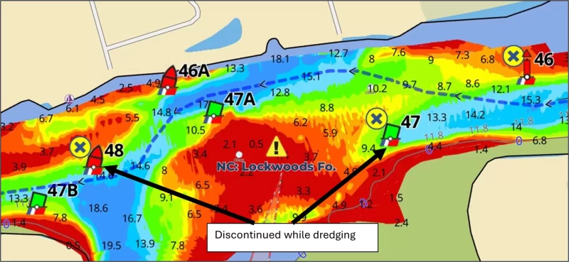
Note: G117C has been reported in a shoal (see chart), leading Captains into shallow water if they tried to honor it; follow the Bob423 track instead for the deepest water.
MM 347.3 Little River Swing Bridge schedule change effective May 5, 2025, through October 31, 2025:
- On Monday through Friday, the bridge will open on the hour and half hour from 7:00 am to 9:00 am and from 4:00 pm to 6:00 pm. The bridge will open on request at other times.
- On weekends and federal holidays, the bridge will open on request.

MM 321 Lockwoods Folly is being dredged. Take the shore route to avoid the dredging operations for 7.0 MLLW. R48 and R47 have been discontinued (moved) while Lockwoods Folly is dredged.

The Ft Pierce A1A bridge at MM 964.8 and the Onslow Bridge at MM 240.6 are still under construction schedules until 5/2/2025. See previous Bulletins for details. The Dismal Swamp is still scheduled to be open 5/5/2025 but call 757-487-0831 to be sure. Railroad bridge #7, next to the Gilmerton Bridge at MM 5.8 has been inoperational for hours at a time this month, most recently for 6.5 hours on 4/26/2025. Call ahead for status at 757-924-5320 or 757-485-5567.
Use Waterway Guide Alerts to plan your trip, adjust your schedule through shallow spots for the tide you need. Follow the Bob423 tracks in Aqua Map to ensure you get the maximum depth possible. The color-coded depth charts are from USACE surveys in Aqua Map. General information on the attractions of America's waterways can be found at WaterwayGuide.com. Additional publications on all regions can be found at the Ship Store. Many helpful articles are available in the Knowledge Center. Explore the Waterway Site for a wide range of help in your cruising adventures.


- 4,000 Marinas
- Thousands of anchorages
- Updated Charts
- Mile-by-Mile Navigation
- Highlighted Alerts & Cautions
- Full-Color Aerial Photographs
The Waterway Guide App Makes it easy to leave reviews, use our explorer, and view waterway guide materials all on the go!